

Iceland Divide (North-South)
ICELAND
HIGH POINT
1140 m
DIFFICULTY (1/10)
9
DISTANCE
554 Km
DAYS
9
% SINGLETRACK
0%
% UNPAVED
80%
TOTAL ASCENT
5672 m
% RIDEABLE TIME
99%
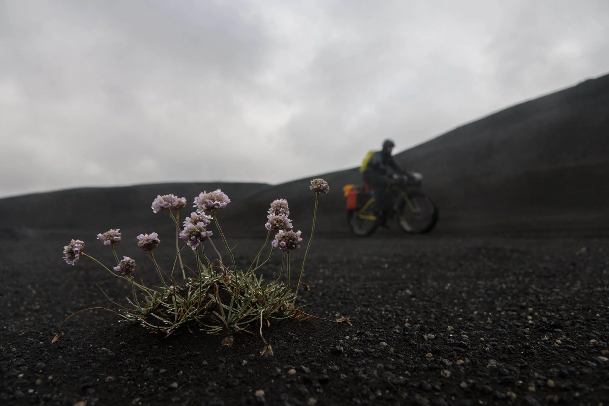
Just below the Arctic Circle, straddling the divide between the North American and Eurasian tectonic plates, a raw and untamed land rises from the depths of the Atlantic. A land sculpted by fire and ice—where massive glaciers, blackened deserts, and towering lava formations shape an otherworldly landscape. Running along the fault line that splits the island from north to south, the Iceland Divide is a route through some of the most desolate and mesmerizing terrain on Earth: the Icelandic Highlands.
Perched between Great Britain and Greenland, Iceland is a volcanic island dominated by an uninhabited plateau at its core—accessible only during the brief summer months when the snow retreats. This route was designed to traverse Iceland from the northern coast to the southern edge, following the Mid-Atlantic Ridge—the very seam where continents drift apart.
The journey kicks off in Akureyri, a small city tucked into Iceland’s longest fjord. From there, the trail winds through endless lava fields, past glacial volcanoes, and into the wildest reaches of the Highlands, where the landscape is as unforgiving as it is stunning. Expect remote doubletrack, rugged gravel roads, and vast expanses of unbroken wilderness.
2018 Best New Routes (9+ days)


-
Desert areas that look like those of the moon for their colors, desolation, and absence of vegetation. There are other places quite like these anywhere else in the world.
Wonderful waterfalls of Aldeyjarfoss, characterized by black basalt columns.
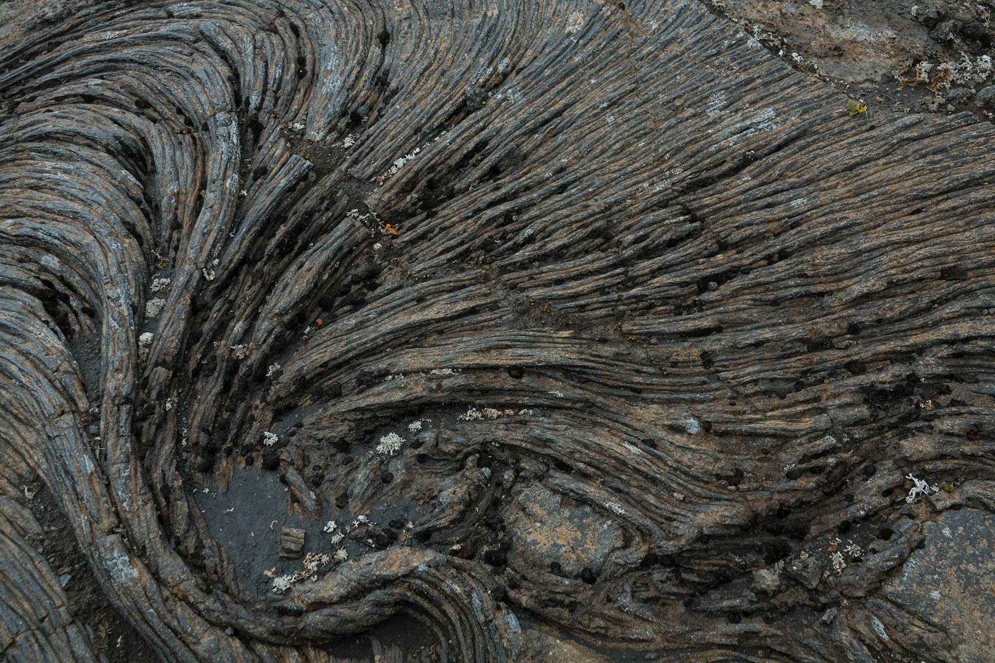
Riding through the solidified lava of the Frambuni lava field, the gateway to the Highlands.
The impressive silhouette of Krakatindur volcano, east of the Fjallabak Nature Reserve, and the primordial environment that surrounds it.
Views of Mount Maelifell, an almost perfectly conical volcano that stands alone in a black sand desert. It’s a stunning natural masterpiece and one of Iceland’s most iconic landmarks.
The tomb of Hjörleifur Hróðmarsson (killed in 875 AD), one of the first Viking explorers, located on the summit of the Hjörleifshöfdi promontory east of Vik. The tomb can be reached on foot through a path that climbs 200 meters along the west side of the promontory.
Hjörleifshöfdi cave on the black sand beach near Vik, with the silhouettes of the sea stacks Reynisfjara and Dyrhólaey standing out on the horizon.
-
The access roads to the Highlands are closed for most of the year due to snow. The period during which it’s possible to ride the route is thus reduced to about three months, from the beginning of June to the end of August.
Bring clothing for cold weather, including a rainproof and windproof jacket.
We recommend a freestanding tent that can withstand strong winds, as the ground is mainly lava sand and doesn’t offer solid anchor points. Use your bike when rocks aren’t available to anchor the tent.
Bring a head net with you. The area near Lake Svartárvatn, gateway to the northern part of the Highlands, is infested with midges.
Public buses offer a valid and cheap connection between the Reykjavik and the towns of Akureyri (start) and Vík í Mýrdal (end). The buses are equipped with bike racks.
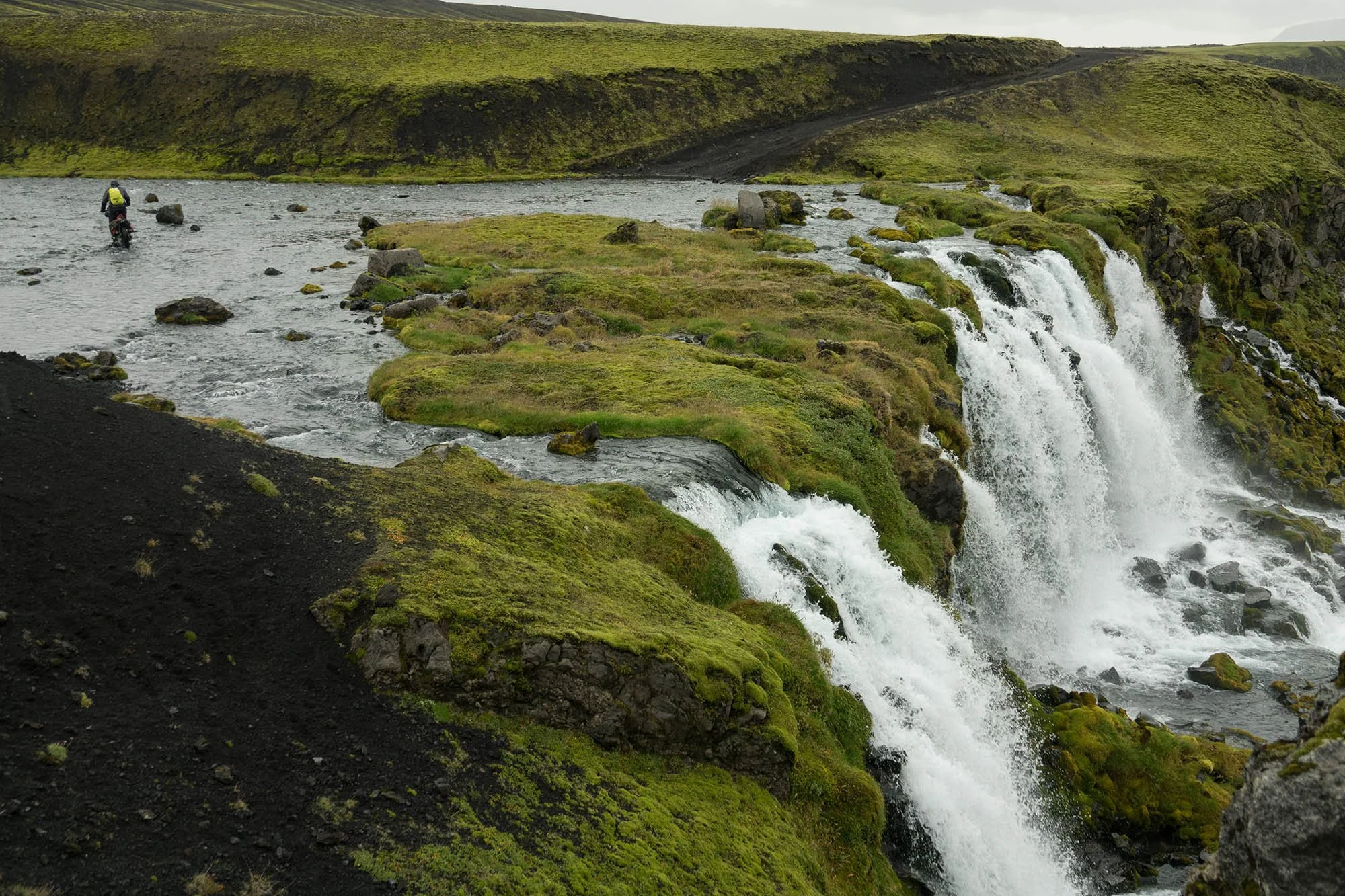
When crossing rivers, always look for the best passage at the moment, given that the flow and the course of the river can vary. The “classic” line for crossing using by 4×4 is often not the best choice for a crossing on foot or by bike. The tires of motor vehicles dig into the bottom of the river, increasing its depth.
River crossings can become dangerous during or after rain, and, in the case of glacial rivers, during warm periods. You may have to wait until late night or early morning to crossing certain glacial rivers during the summer.
In Iceland it’s strictly forbidden to leave the gravel and doubletrack roads, even by bike.
This route is best experienced on a fatbike.
-
In the Highlands, you have permission to pitch your tent anywhere for one night. #leavenotrace.
If you wish to camp near fenced off farmland, you have to ask permission from the landowner before you set up your tent.
There are some mountain huts along the route (see map). You’ll encounter the first two during the initial part of the route, about 8 km apart from each other. The first one is quite spartan and has 16 beds. The second one, Botni hut, also has 16 beds and a kerosene operated stove for heating and gas cooker for cooking. The third one, the Kistufell hut, is located at 1000 m altitude on the slopes of its namesake mountain, in one of the most remote areas of the route. This is a private hut that still remains open and available to those who may need it.
There are also staffed huts along the F26 and F210 where you can eat and sleep (very expensive), or camp in their campsite by paying a fee. There’s no possibility of food resupply here.
-
Water is almost always available thanks to the many rivers and springs, except in the most desertic area between the Askja volcano and the Dyngjujökull glacier. The Kistufell hut has tanks of water inside that are available to those who need it. If these are empty, you must walk to a spring about 1 km southeast (see map).
Never take water from areas downstream of farms or fields. Instead, visit the farms and ask for the tap water.
Water from glacial rivers should be filtered.
-
Leaving the city of Akureyri in the north, located on Iceland’s longest fjord, the route goes inland along a gravel road and then follows doubletrack just beyond the last human outpost, a farm near Lake Svartárvatn. From here, the green of the vegetation becomes sparse as you proceed, and the predominant color fades to the black of a huge stream of solidified lava mixed with lava sand. The desert views in the Suðurárhraun are impressive: devastation, desolation, and loneliness intermingle with an unmistakable feeling of disorientation.
To the south, the scenery becomes gloomy where a doubletrack sneaks along the Askja stratovolcano, over the mountain range Dyngjufjöll, and across the lava field of Frambuni. On the horizon, some lava formations stand out against the whiteness of Vatnajökull glacier, an impressive ice cap and the fourth mass of ice in the world. This is the most remote area of Iceland, and one with environments similar to those of the moon, so much so that in the ’60s, NASA chose this area to prepare the Apollo Astronauts for lunar exploration.
Passing the volcanic glacier Tungnafellsjökull to the north, the route intercepts the F26, a gravel road leading south through the Sprengisandur plateau, a black desert located between the east side of the Vatnajökull glacier and the subglacial volcano Hofsjökull. From the plateau’s 800 m elevation, you descend on a comfortable doubletrack to 250 m where the trail intercepts the F225, a gravel road that returns gradually to the mountainous region of Landmannalaugar in the Fjallabak Nature Reserve, a place known for its multicolored rhyolite mountains and its hot springs.
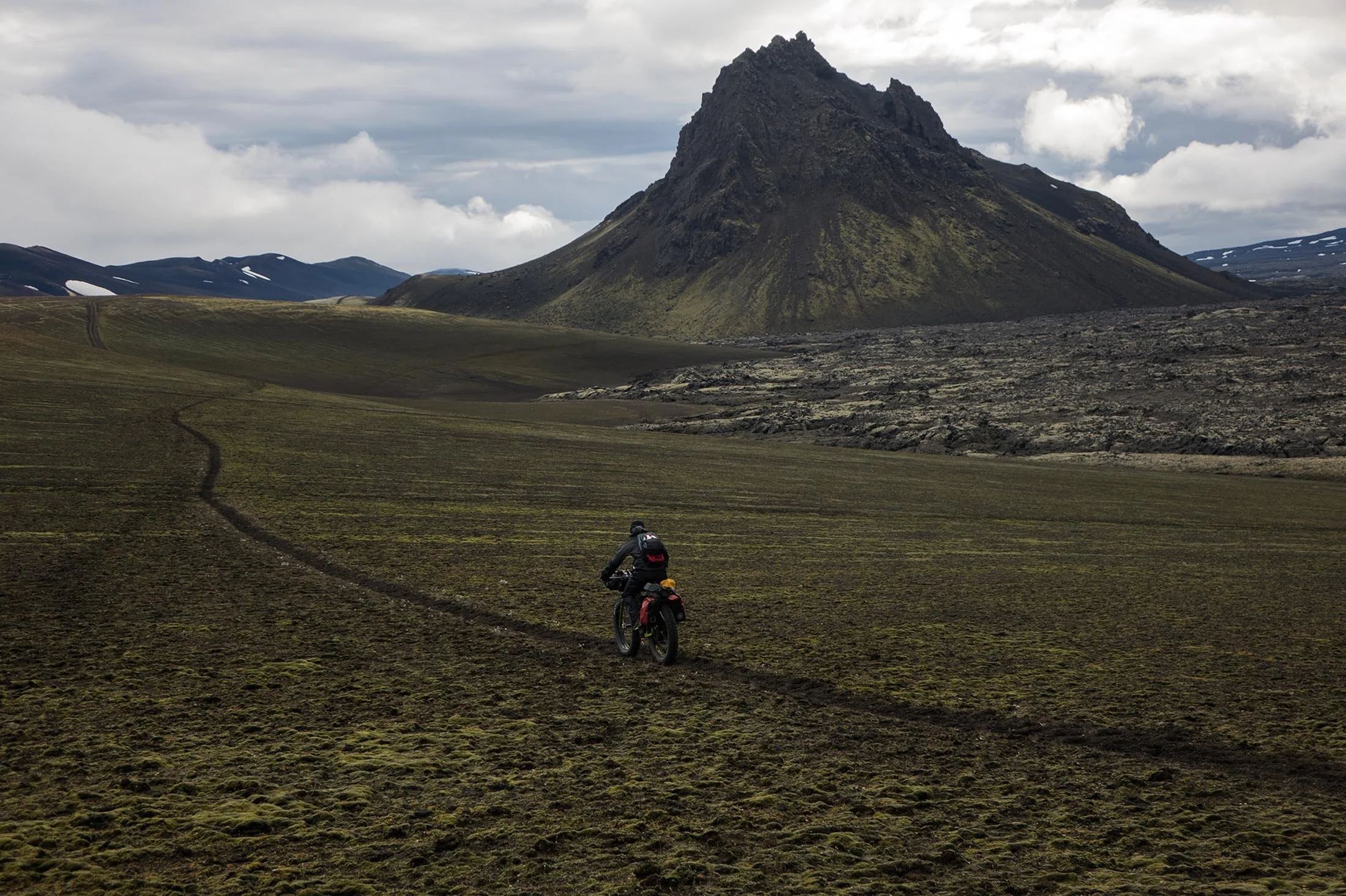
Back up at 600 m, you leave the comfortable gravel road for a doubletrack that rolls up and down before it reaches a desolated area in the direction of the Hekla volcano. Here, the wide expanses of black sand give way to mountains and volcanic formations like Krakatindur, a mass of rock that emerges from the Nyjahraun lava field like a ship’s bow. The view is breathtaking and the strong contrast between the black of the solidified lava flow and the bright green of moss that climbs up its slopes makes the landscape extraordinarily unique and unreal.
The route continues along doubletrack, sometimes using only the yellow posts stuck into the ground for reference, as the tracks are often erased by the floods coming from Mýrdalsjökull glacier, Iceland’s southernmost ice sheet. Continuing on, the trail encounters the distinct shape of Mt. Maelifell, majestic pyramid covered with green moss, sitting in the middle of a black desert. It serves as the exit from the otherworldly Icelandic Highlands. The final stretch of the route rolls on until it reaches the black sands and black pillars emerging from the sea in Vík í Mýrdal, the southernmost village in Iceland.
-
Additional Resources
Road conditions and weather in Iceland: www.road.is
Iceland Public Bus Transportation: www.straeto.is
Weather forecast from Icelandic Meteorological Office
Excellent camping and cheap option to stay in Reykjavik
ROUTE DIFFICULTY: 9/10
The Iceland Divide earns a 9/10 difficulty rating, primarily due to its extreme weather. Rain and wind are near-constant companions, and at higher elevations or mountain passes, hail and even summer snowstorms are not uncommon. But the real beast here is the wind. Storms in the Highlands are legendary, with winds powerful enough to hurl fully loaded bikes like twigs and knock riders off their feet. When conditions turn brutal, moving forward can become impossible. These tempests can last for hours, with sustained winds of 135 mph (225 km/h) and gusts reaching a staggering 165 mph (270 km/h). Beyond the weather, other challenges include scarce food resupply points and deep, fast-flowing river crossings that demand strength, strategy, and sometimes pure grit. For those willing to take on the elements, though, this route offers one of the most extraordinary bikepacking adventures on the planet.
!! WARNING !!
We STRONGLY DISCOURAGE anyone without the necessary skills and mindset for extreme environments—such as mountains, deserts, river crossings, and remote water and food resupply—to follow the routes on this site. These routes are designed primarily for EXPLORATION and are not intended for traditional bike touring. If your experience is solely in cycling, without a solid background in outdoor survival and self-sufficiency, you are STRONGLY ADVISED AGAINST attempting these routes. They demand an adventurous spirit, adaptability, and the ability to handle unforeseen challenges in the field. Proceed entirely at your own risk. While every effort has been made to provide accurate GPS tracks and route information, we cannot guarantee their reliability over time due to factors such as land access changes, property rights restrictions, and the closure of supply points. All the information provided on this site is more than sufficient to ride these routes. Please do not email us requesting additional info about the routes, as you will not receive a response - sorry for that. Further information for every route can be found in the comments on Bikepacking.com (click on “Check it on Bikepacking.com” button). The route creators are in no way responsible for personal injuries, damage to property, or any other incidents that may occur while riding or following these routes.