

Alta Via dei Monti Liguri
Liguria - ITALY
HIGH POINT
2170 m
DIFFICULTY (1/10)
9
DISTANCE
488 Km
DAYS
15
% SINGLETRACK
18%
% UNPAVED
80%
TOTAL ASCENT
21.140 m
% RIDEABLE TIME
95%
The Alta Via dei Monti Liguri (AVML) is a demanding yet breathtaking bikepacking route that stretches across Liguria, a stunning coastal region in northwestern Italy. Nestled between the rugged cliffs of the Cinque Terre and the towering Maritime Alps, this journey follows historic military roads, rocky singletrack, and steep alpine paths. Along the way, riders traverse ancient rural settlements, mystical beech forests, imposing fortifications, and dramatic valleys that drop down toward the Ligurian Sea.
Spanning 488 kilometers, the AVML runs parallel to the coast, linking La Spezia in the east to Ventimiglia, a historic border town near France. Originally designed as a trekking route, the Alta Via was officially established in 1983 as a collaboration between the Centro Studi Unioncamere Liguri, the Club Alpino Italiano (CAI), and the Federazione Italiana Escursionismo (FIE). However, its origins trace back even further—post-war reports from the FIE already mapped a nearly identical route between Colle del Giovo and Colle Cento Croci.
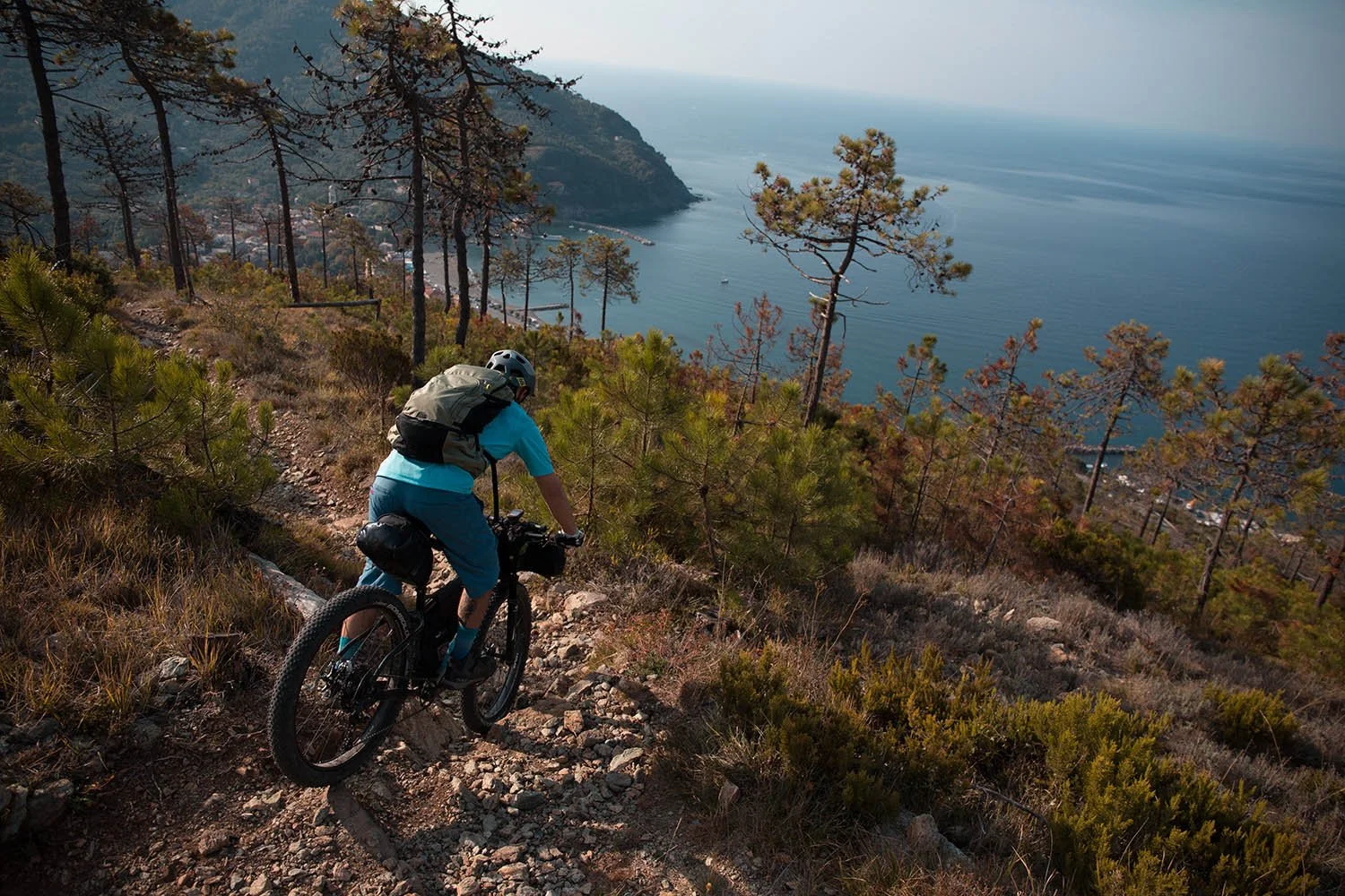
The Route Eastern Section - Wild Cliffs & Coastal Trails The eastern AVML features a mix of dirt roads and singletrack trails, weaving through pine forests, chestnut groves, and dense ferns along the breathtaking Levante coast. Here, the Alta Via delle Cinque Terre (AV5T) leads into wilder terrain, offering sweeping views where rocky cliffs plunge into the sea. One of the most spectacular sections is a technical, rocky descent towards the coastal town of Levanto, followed by a unique stretch through a converted railway tunnel before the climb back up to rejoin the AVML.
Central Section - Liguria’s Hidden Heart North of Genoa, the AVML winds through a mix of dirt roads, singletrack, and deserted B-roads, passing through quaint, tucked-away villages in the Ligurian hinterland. This region is defined by lush meadows, deep forests, and rolling hills, a peaceful contrast before the demanding climbs of the western portion.
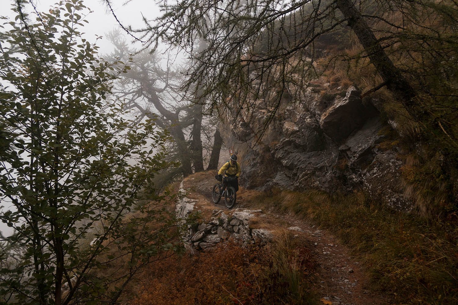
Western Section - The High Alps & Military Roads As the route progresses westward, the terrain becomes more rugged, transitioning from the final slopes of the Apennines to the vast expanse of the Maritime Alps. Here, the scenery shifts dramatically—moss-covered rocks, ancient lichens, and towering conifers dominate the landscape. A steady dirt-road climb leads to Monte Saccarello, the highest point of the AVML at 2.170 meters and the furthest point from the sea (30 km inland). Near the summit, remnants of military ruins mark the region’s strategic past. On a clear day, you can see Corsica to the southeast and the pyramid-like peak of Monviso (3.841m) to the northwest. From Monte Saccarello, the descent towards the sea follows the historic Via del Sale (Salt Road), an ancient trade route once used to transport goods from the coast to northern Europe. The initially smooth dirt road soon gives way to a challenging alpine singletrack, featuring short exposed sections (see Route Difficulty). This thrilling trail leads to the Gola di Gouta, before a rugged, former military road overlooking the Nervia Valley finally descends into Ventimiglia, marking the end of the AVML.


-
Traveling a unique route that starts from the sea to reach the Alps.
The incredible view of the cliffs overhanging the Cinque Terre.
The extraordinary view offered by the top of Mount Saccarello, where you can see on one side the entire chain of the Cottian Alps and Corsica on the other one.
The descent towards Levanto with the sea in the background.
Several old fortifications on the west side.
Traditional dishes of the local gastronomic culture. Liguria is home to “Genoese Pesto”.
-
To facilitate the return by train once the route has been completed, the track starts from the La Spezia railway station and ends at the Ventimiglia station, whatever the direction of travel chosen.
The railway line runs along the coast and always remains between 15 and 20km from the route, so that the AVML can be traveled even partially, reaching the intermediate stations along the coast.
The best time to tackle this route is from June to October as the Alpine section can be covered by snow through the spring.
Bring mountain clothing, as there can be rapid changes in weather and sudden temperature drops at high altitudes, even during the summer months.
The AVML can be ridden from La Spezia towards Ventimiglia or from the opposite direction.
Most of the route is marked with red/white/red flags with the letters AV in the middle. The initial stretch that passes through the Cinque Terre is marked with the letters AV5T.
To ride this route we recommend a plus-tire bike with suspension fork.
-
Wild camping is generally tolerated. Best to set up camp at dusk and move on at dawn. #leavenotrace
In some parts of the route there are small cabines or votive chapels, which in case of need, can be used as shelter for the night.
Along the route there are also several accommodation facilities, from cabines to hotels.
-
Generally speaking, there are plenty of hotels, restaurants, bars, and general markets along the route so food is never a problem.
Water is not a problem either, there are few sources and several livestock fountains. In the villages you will almost always find a fountain where you can refill.
Sometimes in the larger towns there are general stores.
You can satisfy your huge caloric deficit at “Hotel Paretin”, an hotel-restaurant located at Cabanne. Their traditional ligurian cuisine is simply delicious, and the portions are massive!
-
Additional Resources
altaviainfoh24.com provides a range of services regarding AVML, including a telephone assistance service for Alta Via visitors, free and available 24 hours a day, in 3 languages (Italian, English and French)
BeActiveLiguria.it For additional route and tourism information in the area.
Route Difficulty: 9/10
The AVML is not for the faint of heart. Its greatest challenge is the massive 20000-meter elevation gain, demanding strong physical endurance and proper preparation. Liguria’s unpredictable weather adds another layer of difficulty—fog, sudden rain, and temperature swings are common in the mountains, even with the sea nearby. Expect some hike-a-bike sections over rocky terrain, and take extra care on the Fonte Dragurina pass (1.810m), where a short via ferrata (marked on the map) requires caution, especially with a fully loaded bike (see gallery photos).
!! WARNING !!
We STRONGLY DISCOURAGE anyone without the necessary skills and mindset for extreme environments—such as mountains, deserts, river crossings, and remote water and food resupply—to follow the routes on this site. These routes are designed primarily for EXPLORATION and are not intended for traditional bike touring. If your experience is solely in cycling, without a solid background in outdoor survival and self-sufficiency, you are STRONGLY ADVISED AGAINST attempting these routes. They demand an adventurous spirit, adaptability, and the ability to handle unforeseen challenges in the field. Proceed entirely at your own risk. While every effort has been made to provide accurate GPS tracks and route information, we cannot guarantee their reliability over time due to factors such as land access changes, property rights restrictions, and the closure of supply points. All the information provided on this site is more than sufficient to ride these routes. Please do not email us requesting additional info about the routes, as you will not receive a response - sorry for that. Further information for every route can be found in the comments on Bikepacking.com (click on “Check it on Bikepacking.com” button). The route creators are in no way responsible for personal injuries, damage to property, or any other incidents that may occur while riding or following these routes.